The public reaction to Apple's new iOS 6 Maps application has been visceral thus far. There have been numerous complaints about Maps taking people to the wrong locations, directing them to businesses that have long been closed, and visually displaying less local and contextual data than Google Maps. Indeed, these are all turning out to be common frustrations among iOS 6 upgraders—I mentioned many of them in our review of iOS 6—prompting Apple to swear the app will be improved over time.
But one major omission from the Maps app that isn't likely to make a reappearance (at least from Apple) is transit directions. Apple stated that it ignored this feature in Maps in an attempt to open things up for third-party developers. The company line is that the best transit apps are ones that are tailored to each city. This may be true to some degree, but as I wrote in my iOS 6 review, I think this is a wildly user unfriendly move regardless of the motivation.
Apple appears to be sticking to its guns and is unlikely to reverse course anytime soon on the decision to put the transit responsibility on developers. Developers, on the other hand, appear to be cautiously optimistic about the move. Indeed, they appear excited about the possibilities, with many asserting a belief that the user experience will end up being better overall—once the early kinks are worked out.
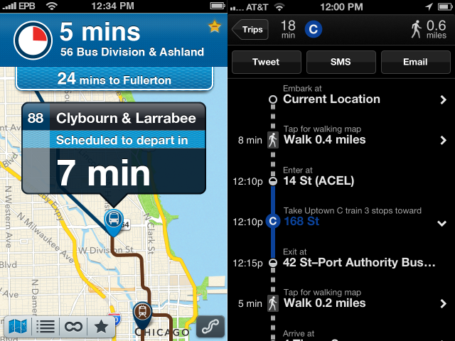
How do transit apps plug into Maps anyway?
When a user enters a start and end point into the default Maps app and selects the transit button (instead of say, driving or walking), Maps automatically searches for any transit apps that might already be installed on the device. If there aren't any, it searches the App Store for apps based on geolocation—if you're in Chicago, it will bring up transit apps that are made for Chicago. If you're in London, it'll bring up ones for London, and so on. Users can still search for transit apps for all cities manually, but Maps aims to bring up only results for the city you're in—presumably to help weed out the cruft when all you want to do is get to your hotel.
Existing transit apps can't automatically plug into Maps, though. Developers have to tell Apple that they're making a transit app and provide a boundary for the area they're serving in order for it to function with Maps. When they do this, it allows their apps to function both as a standalone app and as a plugin to Maps.
Developers appear excited about this even if it involves significantly more work. Cieslak and his partner Jacob Van Order (who has his own app called QuickTrain) told me they teamed up in part because they needed to come up with their own way to actually route the user between point A and point B. When Maps calls their new app (Buster 3, to be released next week) with a beginning and end point, Buster will hand the data to a server using Open Trip Planner. OTP returns a "huge JSON file," which Buster 3 then uses in combination with Apple's MapKit to plot out the lines and provide an itinerary.
All this allows developers to offer a wider variety of transit options than what was available previously under Google's Maps app (which was largely limited to trains and busses in most cities). And because of the added transportation options, developers have the ability to provide users with even more customized routing options. TripGo developer Adrian Schoenig told Ars that his company's app can offer combinations of options—such as taking your car to the train station, taking the train into the city, and taking a cab to your final destination.
Such flexibility does sound appealing from a user's point of view. Cieslak and his partner Van Order added that Buster 3 will be able to "favorite" entire routes instead of individual stops thanks to the changes they're making. So if you're always taking a series of trains and buses to get to work, you can keep that route bookmarked for future use. And their app will also send push notifications to get off or transfer at certain locations, too, so you don't forget in case you're reading a book or engaging in a heated Twitter argument.
Opportunity is knocking
Indeed, the most common message I received from developers about this change was that they were hesitant to add significant new features before due to the limited audience. But now that Apple has unceremoniously shoved responsibility for transit into their hands, they've been motivated to step up and create some truly useful apps that they might not have done before.
"Developers have a lot of new opportunities because now transit apps are in high demand," developer Tim Desir told Ars. "Also, Apple is giving out free advertisement by including developers apps in a system app that everyone will see."
Schoenig agreed. "It's better for us developers and better for Apple. Users will feel short-term pain due to the lacking quality of Apple's maps and possibly lack of high-quality transit apps for where they are. In the medium- and long-term it will be an overall gain. It's better for innovation," Schoenig said.
"Now we have a chance to do something better than the Maps in iOS 5 and actually have an audience for it," Van Order said.
And it's important to remember that while Google's version of Maps worked reasonably well when it came to transit, it was still limited in many ways. Arrival and departure times were often wildly inaccurate. And Google was unable to take into account service changes, train or bus line shutdowns, and other details that would affect a user's route. To be sure, any regular transit user had their frustrations with the iOS 5 version of Maps as well, which is why some developers believe this change has the potential for good.
Embark developer David Hodge was quick to point this out. "Google, in its efforts to cover every single city, provides mediocre results in key big cities like NYC and SF. These big cities require a level of attention to detail that is difficult to achieve at scale. Apple instead chose to empower its app developers to make public transit apps," Hodge told Ars. "This is why we go in to cities like New York and figure out details like walking speeds and transfer times because that makes all the difference in providing accurate transit results.
"We think this is a great move for the space. Just like the early days of the App Store, Apple has opened up a large opportunity for developers to further innovate and improve public transit apps. Going into the iOS 6 launch, we were planning about 4 million mass transit trips per month for our users. Based on what we've seen with iOS 6 in the last 24 hours, that rate should be increasing by an order of magnitude shortly. So we've benefited thus far."
Still a user-unfriendly move
The developers are generally optimistic about their prospects, but they're still just "regular" users in their everyday lives. And from that perspective, they're more than willing to acknowledge that the situation is less-than-ideal—at least for now.
"I was really disappointed that transit was removed at first. I wasn't buying the 'developers make the best transit apps,'" Desir told Ars. "I really think that it's good for developers who want to make something better, but bad for the 'average user' and people who heavily rely on public transportation and don't know much about other apps on the App Store. It was a risky decision to do this."
Indeed, despite their optimism, almost all the developers I spoke to acknowledged that things won't be easy for users. "I personally used the transit directions in the Maps app almost every day, and haven't found a full-featured replacement that I like yet, so I find it pretty frustrating," developer Peter Stuart told Ars. "Right now things are definitely worse, but I think that eventually third-party apps will offer the same features and potentially be even better."
Some echoed my comments from the iOS 6 review, pointing out that users will have to learn something new in order to achieve the same level of functionality. That, combined with the inconsistent transit experience between cities, will undoubtedly provide challenges to the iOS 6 userbase.
"The only difficult part is the learning curve users will have to go through," Desir added. "All the transit apps will do the same thing, but will present it differently. It just sucks that some people will have to re-learn how to do what they've been doing for the past couple years."
Not all developers were as optimistic about the long-term possibilities for their apps, though. "The 3D maps are amazing, but they are meaningless if the core features of getting you from point A to point B aren't working," developer Greg Raiz told Ars. "I believe there may be a short-term opportunity for regional app developers, but long-term I see this being an area that's incorporated into the OS. I suspect the sheer number of issues prevented Apple from tackling transit directions; I expect this will be back. "
reader comments
85