
Apple ramps up Maps effort, rides into more U.S. states this month for imagery

Apple Maps van
Image used with permission by copyright holder
Apple’s camera-equipped cars have recently been mapping cities in the U.S. and beyond as the company steps up its effort to build out its Maps offering and – although it’s been a long time coming – take the fight to Google.

An update on Apple’s website reveals the company is gearing up to take its cars to various counties in 24 U.S. states by the end of this month, as well as multiple locations in the U.K. and Ireland, including London and Dublin.

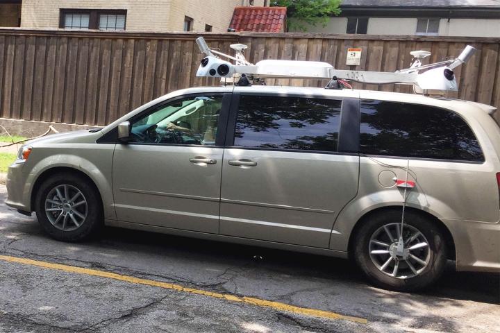
The company announced last month that it’d be driving its vehicles “around the world” to collect data for its Maps offering. Specifically, Apple is believed to be gathering imagery of business storefronts to take the place of Yelp data which is currently used by its Maps app, and also 3D street-level photos to complement its Flyover feature that offers Maps users an aerial view of a number of cities and famous landmarks.

Assurances by the tech giant stating its intention to “blur faces and license plates on collected images prior to publication” suggest Apple is also looking to build a database of Google-style Street View imagery for its app.

Recent reports claim the Cupertino company is looking to switch to an in-house mapping database in the next three years. The move would lessen its reliance on third-party data providers such as TomTom.

Following a troubled launch in 2012, Apple has been working diligently to bring its Maps offering up to speed, making a number of startup acquisitions and hiring a slew of skilled engineers along the way.

Editors' Recommendations

Trevor Mogg
Contributing Editor
Not so many moons ago, Trevor moved from one tea-loving island nation that drives on the left (Britain) to another (Japan)…
Apple Maps enhances road trips with multistop routing, transit fares
Apple Maps running on an iPhone and MacBook Pro.

Amid a barrage of updates to iOS 16's lock screen, Apple Pay, and more, Apple also used its WWDC 2022 keynote to unveil several changes to Apple Maps. While Apple Maps has long been the butt of many jokes, Apple's mapping application is poised to get a few key features this year, including multistop routing, new transit information, and more detailed maps in more cities and countries.
Multistop routing
Multistop routing is the highlight of this year's Maps update, and it's bound to be the most useful for folks. With this update, Maps users can create a route with up to 15 stops on the way to their final destination. Planning a big road trip and want to schedule a few stops at gas stations or restaurants along the way? Multistop routing lets you do that. You can create multistop routes directly on your iPhone or on your Mac and send them to your iPhone when you're ready to hit the road.

New transit features
Another standout feature is how Apple Maps is improving transit information. While traveling or planning your route, Apple Maps will show you any upcoming fares and how much they'll cost — ensuring there are no surprise costs along the way. But Apple Maps doesn't stop there. If you have a transit card saved in Apple Pay (which was also just updated at WWDC 2022), Apple Maps will show its remaining balance and alert you if it needs additional funds.
Better maps for more users
Beyond those functional changes, Apple Maps is also getting a few significant visual improvements. Developers can use the MapKit API to integrate enhanced visuals in select cities. This includes high-resolution renders for homes on Zillow, and Bird making its bikes and scooters more easily visible.

Read more
Apple Maps brings major update to Canadian cities
An iPhone 13 in the hands of a user.

Apple Maps ushered in new, detailed 3D city maps with the release of iOS 15 and now Canada's biggest cities have been added to the feature. Apple device users are able to view Montreal, Toronto, and Vancouver in more detail than ever before using Apple Maps, according to an announcement made by Apple. The update provides much more precise environmental information as the app shows individual buildings and landmarks, giving users the ability to truly make sense of their surroundings.

When the feature debuted in a handful of American and English cities, users were impressed with the level of detail in each map. But the number of cities available was a little disappointing to anyone outside of the U.S. and London, so bringing detailed 3D maps to another country is an exciting development for the tech.

Read more
MediaTek looks for more U.S. success with Dimensity 8000
MediaTek Dimensity 8000 chip.

MediaTek is now the number one supplier of mobile processors for Android smartphones in the U.S., according to research from IDC, and it has announced a pair of new chips, plus news about its mmWave 5G modem, which it hopes will help continue to drive its great momentum. The Dimensity 8000 and Dimensity 8100 processors are a step down from the Dimensity 9000 platform, but are still expected to compete with the Qualcomm Snapdragon 888 in terms of power thanks to a more modern modem and greater efficiency.

The Dimensity 8000 will find a home in premium 5G Android smartphones, and has been built using a 5nm process, unlike the high-specification 4nm Dimensity 9000. The octa-core Dimensity 8000 chip uses four Arm Cortex A78 cores at 2.75GHz, along with four Arm Cortex A55 cores, while the slightly faster Dimensity 8100 uses the same Cortex A78 cores at speeds up to 2.85Ghz. The two are otherwise identical.

Read more